Snowshoeing route Neustift - Forchach - Innere Mahd (2)
ważne informacje
Długość trasy
4 km
Całkowity czas trwania trasy
02:30 h
Wysokość metry pod górę
263 hm
Najwyższy punkt
1635 hm
Trudność
średnia
podróż samochodem:
In Milders turn off in the direction of Oberbergtal and then follow the signs for Kartnall.
parking:
After the tunnel, you’ll find numerous free parking spaces at the fork in the trail on the right-hand side.
punkt początkowy:
General car park (approx. 300 m above Forchach)
punkt końcowy:
General car park
najlepsza pora roku:
Sty
Luty
Mar
Kwie
Maj
Cze
Lip
Sie
Wrz
Paź
List
Grud
profil wysokościowy
pogoda
opis
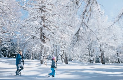
The starting point is approx. 400 metres after the tunnel, directly after the fork in the road on the right-hand side. Following the forest path, the hike leads you from here through idyllic winter forests to Innere Mahd. The Hofer snack stop and Kartnall snack stop are wonderful places to stop for refreshments. You get to them by following the tarmac road for approx. 500 metres.Refreshment options: Jausenstation Hofer – Unterkartnall (1,300 m), Jausenstation Oberkartnall (1,285 m)