Winter hiking trail Schlickeralm (15a)
ważne informacje
Długość trasy
5.2 km
Całkowity czas trwania trasy
02:00 h
Wysokość metry pod górę
372 hm
Metry wysokości w dół
363 hm
Najwyższy punkt
1664 hm
Trudność
średnia
Wytrzymałość
3/6
Umiejętność
3/6
punkt końcowy:
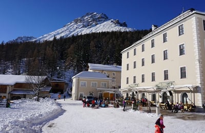
Alpengasthof Schlickeralm
warunek ścieżki:
Breiter auch als Fahrweg genützter Winterweg
sprzęt:
Sehr gute Schuhe mit Profilsohle (bei Vereisung
najlepsza pora roku:
Sty
Luty
Mar
Kwie
Maj
Cze
Lip
Sie
Wrz
Paź
List
Grud
profil wysokościowy
pogoda
opis
Walking Time: approx. 2 hoursLength: 5.2 km (total)
Difference in Altitude: 286 m
Start / Finish: Froneben Intermediate Station
Parking: Valley Station Schlick 2000
Rest Points: Schlickeralm (1,643 m), Fronebenalm (1,306 m), Bruggeralm (1,350 m)
The winter hiking trail Schlickeralm is located in the Schlick 2000 ski area. It starts at the middle station Froneben and takes approximately 1 hour to walk through the Schlicker Talboden to the Schlickeralm.
After a cozy stopover, you follow the same path back to the middle station Froneben. Then, you can relax by taking the cable car back down to the valley.