Seven Summits - Elfer
ważne informacje
Długość trasy
7.48 km
Całkowity czas trwania trasy
04:20 h
Wysokość metry pod górę
755 hm
Metry wysokości w dół
750 hm
Najwyższy punkt
2489 hm
Trudność
średnia
Wytrzymałość
2/6
Umiejętność
2/6
podróż transportem publicznym:
From Innsbruck main train station direct bus to Neustift im Stubaital.
podróż samochodem:
From the Olympic city of Innsbruck you reach the Stubai valley via the Brenner motorway ( Europe Bridge ) , exit Schönberg - continue to Neustift.
parking:
There are plenty of free parking at the ground station .
punkt początkowy:
Mountain station Elferbahn (1794 m)
punkt końcowy:
Mountain station Elferbahn (1794 m)
warunek ścieżki:
Characteristics: Hiking (red mountain track)
najlepsza pora roku:
Sty
Luty
Mar
Kwie
Maj
Cze
Lip
Sie
Wrz
Paź
List
Grud
profil wysokościowy
pogoda
opis
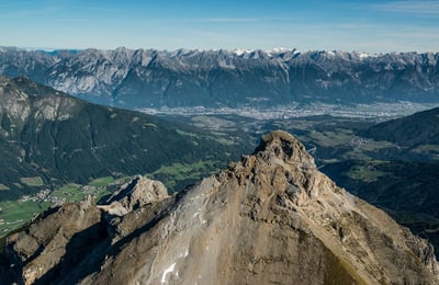
THE SHY ONEPosing for the cameras and nevertheless not attracting too much attention. Every day at 11 am the sun lights up its back to present it in the spotlight, as seen from Neustift, however some of its glory is hidden shortly thereafter. You must hike up the Elfer to capture all of its beauty because at close range its rocky towers and spikes are much more impressive. Even though the blunt Dolomite rocks situated on a foundation of primary rock and the rocky formation of the Elferspitze and its Elfer towers may remind you of the Dolomites, the “home mountain” of the Neustift inhabitants with its glacial peaks of the Stubai Alps knows where it belongs. Proud and glorious on the one hand, shy and insecure on the other, the Elfer knows how to confound its spectators. While the summit cross at the eastern Elfer tower (2,499 m a.s.l.) leads you to believe it is the highest point, the main summit, also known as Elferkofel (2,505 m a.s.l.), doesn’t want to be forgotten.
Proud neighbors
It is perfectly fine if you let your eyes wander from the Elferspitze in all directions. As the rather shy one of the Seven Summits, this peak is not disappointed if it does not get all of the attention. The Serles ridge with the Kirchdachspitze (2,840 m a.s.l.) in the east, the Karwendel mountain range in the northeast and the Kalkkögel mountain range with the Schlicker See Spitze (2,804 m a.s.l.) opposite it in the northwest like to be in the limelight.
Challenging climbing
It is easy to understand why the Dolomite spikes of the Elfer always have attracted climbers. Fritz Kasparek, one of the first ascendants of the Eiger north face, discovered the Elfer in the ‘40s as a climbers mountain while he was stationed at the army high mountain school in Fulpmes during World Word II, erected to educate young commissioned officers. Still to this day, the pitons of his route are visible. ASCENT
From the top station of the Elfer cable car, a winding path leads up for about 30 minutes to the Elferhütte. Then, follow the distinctive ridge uphill in the direction of Elferspitze. Shortly before the summit, you reach the Elfer saddle. There, turn right and hike up the short rope-secured passage for a few minutes until you reach the Elferspitze. Altogether it will take you approximately 2 to 2.5 hours
to ascend.
TOUR DESCRIPTION
ASCENT
From the top station of the Elfer cable car, a winding path leads up for about 30 minutes to the Elferhütte. Then, follow the distinctive ridge uphill in the direction of Elferspitze. Shortly before the summit, you reach the Elfer saddle. There, turn right and hike up the short rope-secured passage for a few minutes until you reach the Elferspitze. Altogether it will take you approximately 2 to 2.5 hours to ascend.
DESCENT
Go around the Elferkofel on the south side and you will reach the Zwölfernieder within about 3/4 of an hour. From Zwölfernieder, a small but nice path going slightly down leads to the eastern flank of the Elfer and then almost flat to the Elferhütte. This route takes about 2.5 hours. Alternatively, you can descend from Zwölfernieder to the north via the Autenalm (1,655 m a.s.l.) or to the south via Karalm (1,737 m a.s.l.).