Deutsch
 English
 Italiano
 Polski
 Čeština
 Français
 Nederlands


Scenic nature site : Kartnall Variant 2
ważne informacje
free parking places at the leisure centre in Neustift, behind the Tourist office in Neustift, or at the Oberbergtal power station in Milders
profil wysokościowy
pogoda
opis
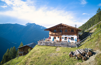
Due to regular floods in the Stubai valley bottom, the farmers were looking for alternative land. They found a profitable “quarter” of land at the end of the 13th century in Kartnall (Romanic “quartinale”). The lower and the upper “Kartnallhof” (farmyard) were built, where livestock and dairy farming as well as limited cropping secured existence. Royalties in kind (1/10 of receipts) had to be paid to the owner of the land, the parish of St. Nikolaus in Hall, as a compensation for farming the fields. Today tourism as well as the cows, sheep and goats secure the existence of the two family farms. The animals graze the grassland; their milk is used to produce butter, grey cheese and curd cheese.TOUR DESCRIPTION
The farmsteads in Kartnall date back to the 13th century and were built due to a fear of flooding in the cleared countryside areas above the valley. From the Neustift leisure centre, we walk along the road in the direction of Freibad and reach the path to Kartnall, which is accessible from April until October. We wind our way through a patch of woodland. After 45 minutes once the wood has thinned out and the trail has climbed gently on its approach to the farmsteads in Kartnall, we reach the Kartnall Naturschauplatz viewing area. Surrounded by green meadows, it offers a wonderful panoramic view across to the Sulzenauferner glacier. Situated at 1,285 m, the Kartnall and Hofer refreshment stops offer a pause for breath with Tyrolean delicacies. From the Kartnall villages we follow the road to the Forchach mountain farm above Milders.
In dry weather, we climb left from here in the direction of Milders.
However, in wet weather and outside the summer season, we follow the road in the direction of Oberbergtal. From the small Milders power station, we walk along the Oberbergbach stream. At the mouth of the Oberbergbach in the Ruetz, we follow the path back to the centre of Neustift.